March 31, 2014
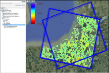
The Government of the Northwest Territories (GNWT) Department of Environment and Natural Resources (ENR), working with their partners, has begun mapping surficial displacement in areas of the NWT through the use of satellite mapping (DInSAR), allowing areas susceptible to permafrost slumping or heaving to be identified across 10 sites. These sites were Tuktoyaktuk, Norman Wells, Fort Simpson, Yellowknife, Tulita, Fort Providence, Hay River, Inuvik, Conoco EL470, and along the Inuvik to Tuktoyaktuk Highway.
Click here for Information Note
ISSN:
2291-3409
Territory: